10 Emerging Trends in Geospatial Technology for Agriculture

Trends in Geospatial Technology

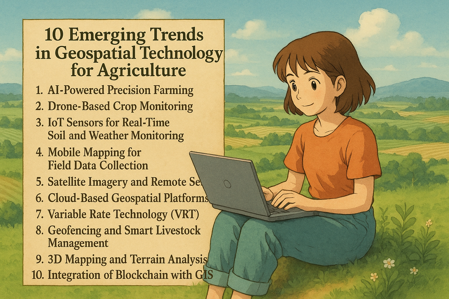
In the age of smart farming, geospatial technology is transforming how we grow food and manage land. With the integration of GIS (Geographic Information Systems), AI (Artificial Intelligence), drones, mobile mapping, and the Internet of Things (IoT), agriculture is becoming more efficient, sustainable, and data-driven. This blog explores 10 emerging trends in geospatial technology for agriculture that are shaping the future of food production. 10 Emerging Trends in Geospatial Technology 1. AI-Powered Precision Farming Artificial Intelligence (AI) is at the forefront of the precision agriculture revolution, enabling farmers to make data-driven decisions with remarkable speed and accuracy. By leveraging machine learning algorithms, AI systems can process vast amounts of data collected from satellites, drones, sensors, and farm equipment. One of the key benefits of AI in agriculture is its ability to analyze real-time data such as weather patterns, soil composition, crop health indicators, and historical yield records. This data is then used to generate actionable insights that help farmers: Predict crop yields more accurately Identify and prevent pest infestations or crop diseases before they spread Optimize irrigation schedules and nutrient application Reduce input waste (fertilizer, water, pesticides) while maximizing outputs When integrated with Geographic Information Systems (GIS), AI becomes even more powerful. AI and GIS integration allows farmers to visualize spatial data through interactive maps, identify problem zones in specific fields, and apply resources only where needed—minimizing costs and environmental impact. For example, AI models can detect subtle changes in plant coloration from satellite or drone imagery to flag early signs of crop stress. Combined with GPS-enabled machinery, this allows for targeted interventions down to the square meter. In addition, AI is also being used in automated machinery like self-driving tractors and smart harvesters, further advancing precision farming techniques. As agricultural challenges grow—ranging from climate change to population pressure—AI-powered precision farming is becoming essential for sustainability, profitability, and global food security. Keyword Focus: AI in agriculture, precision farming, AI and GIS integration, smart farming with AI, AI crop prediction, geospatial AI agriculture 2. Drone-Based Crop Monitoring The use of drones in agriculture has rapidly evolved from a novelty to a necessity. These Unmanned Aerial Vehicles (UAVs) are now essential tools for modern precision farming, offering a fast, efficient, and highly accurate way to monitor large agricultural fields. Equipped with multispectral, hyperspectral, and thermal sensors, crop monitoring drones can capture detailed aerial imagery that the human eye simply cannot detect from the ground. These high-resolution images help farmers observe: Plant health and stress through vegetation indices like NDVI (Normalized Difference Vegetation Index) Water distribution to identify over- or under-irrigated areas Pest infestations and disease outbreaks at an early stage Crop emergence and growth uniformity across different field zones Storm or drought damage assessment in real-time Drones provide frequent and flexible data collection, allowing farmers to monitor crops at any growth stage and respond quickly to issues. This is particularly useful in large-scale farming operations where traditional scouting methods are labor-intensive and time-consuming. In addition to monitoring, some drones are now used for precision spraying of pesticides and fertilizers. These spraying drones reduce chemical usage by applying inputs only where needed, improving environmental safety and lowering operational costs. Another major benefit of UAV mapping is the ability to generate 3D terrain models and orthomosaic maps of fields. These maps assist in planning irrigation systems, analyzing drainage, and managing soil erosion—all critical factors for sustainable farming. With advancements in AI and automation, the future of drone-based agriculture looks even more promising. Autonomous drone fleets, real-time AI analysis, and live data streaming are just a few innovations on the horizon. Keyword Focus: drones in agriculture, crop monitoring drones, UAV mapping, drone crop health analysis, drone farming technology, precision agriculture drones 3. IoT Sensors for Real-Time Soil and Weather Monitoring The Internet of Things (IoT) is revolutionizing smart agriculture by enabling real-time data collection from fields through interconnected sensors and devices. These IoT in farming systems provide farmers with continuous, accurate, and location-specific information about their crops, soil, and environmental conditions. IoT sensors can be deployed across farmlands to monitor crucial variables such as: Soil moisture levels to prevent over- or under-irrigation Soil temperature to determine optimal planting and harvesting times Ambient temperature and humidity for better pest and disease control Rainfall and weather patterns for forecasting and planning field activities When this data is integrated with GIS platforms, it becomes even more powerful. GIS allows farmers to visualize sensor data on digital maps, identify patterns, and make precise, field-specific decisions. For example, a farmer can set up an automated irrigation system that responds to real-time soil moisture readings, reducing water waste and improving crop health. This form of real-time soil monitoring helps in: Smart irrigation management—watering only where and when needed Fertilizer application optimization based on soil nutrient data Early warning systems for drought, frost, or extreme weather events Efficient resource planning and reducing environmental impact The integration of IoT in farming is also paving the way for predictive analytics, where collected data is used to model future scenarios—such as expected yields or pest outbreaks—enabling proactive farm management. As 5G networks and cloud-based analytics continue to grow, IoT applications in agriculture will become faster, more reliable, and more scalable, even for small and medium-sized farms. Keyword Focus: IoT in farming, smart agriculture, real-time soil monitoring, IoT sensors for irrigation, agricultural weather sensors, precision farming with IoT 4. Mobile Mapping for Field Data Collection With the rise of smartphones and tablets equipped with built-in GPS, mobile mapping has become an essential tool in modern agriculture. Using mobile GIS apps, farmers, agronomists, and field technicians can now collect, edit, and analyze georeferenced data directly from the field—without the need for expensive or bulky equipment. This approach to field data collection using GIS enables real-time decision-making, enhances data accuracy, and reduces delays between observation and action. Users can: Mark field boundaries or specific problem areas Record observations such as pest infestations, crop diseases, or irrigation issues Capture geotagged photos and notes for later analysis Upload data … Read more

20 Best Remote Sensing Software for Professionals

Remote Sensing Software

Remote sensing has become a critical tool in various industries, including environmental monitoring, agriculture, urban planning, and disaster management. With advancements in technology, numerous remote sensing software solutions are available to process, analyze, and visualize satellite and aerial imagery. This article lists the 20 best remote sensing software tools that professionals can use for their geospatial and earth observation needs. 20 Best Remote Sensing Software Here’s a list of 20 Best Remote Sensing Software for Professionals you can start using today: 1. Google Earth Engine Platform: Web-based Key Features: Cloud computing, vast data catalog, AI/ML integration Google Earth Engine (GEE) is a cloud-based platform that provides access to a vast repository of geospatial datasets and remote sensing tools. It supports advanced analytics, machine learning, and data visualization. Users can leverage its computational power to analyze massive amounts of satellite imagery, making it ideal for large-scale environmental and climate studies. 2. ArcGIS Pro Platform: Windows Key Features: Advanced spatial analysis, 3D visualization, deep integration with GIS ArcGIS Pro by Esri is one of the most powerful remote sensing software tools. It supports raster analysis, geostatistics, and integration with AI models for enhanced imagery interpretation. The software enables users to conduct high-precision spatial analysis, overlay multiple datasets, and integrate real-time data streams. 3. QGIS Platform: Windows, macOS, Linux Key Features: Open-source, plugin support, raster and vector analysis QGIS is a widely used open-source GIS software that supports remote sensing tasks through plugins like the Semi-Automatic Classification Plugin (SCP) for image classification. It allows for extensive customization and scripting using Python, making it a versatile tool for research and academic purposes. 4. ERDAS IMAGINE Platform: Windows Key Features: AI-driven classification, photogrammetry, LiDAR analysis ERDAS IMAGINE is a leading software for raster-based remote sensing, supporting high-level geospatial analytics and machine learning. It excels in photogrammetry, 3D terrain modeling, and satellite image analysis, making it a preferred choice for professionals in urban planning and land-use management. 5. ENVI Platform: Windows Key Features: Hyperspectral analysis, SAR processing, AI integration ENVI is a premier tool for remote sensing professionals, particularly for analyzing hyperspectral and synthetic aperture radar (SAR) data. It includes robust tools for automated feature extraction, atmospheric correction, and multi-temporal analysis, helping researchers derive meaningful insights from satellite and aerial imagery. 6. SNAP (Sentinel Application Platform) Platform: Windows, macOS, Linux Key Features: Multi-mission support, free Sentinel data processing Developed by ESA, SNAP provides advanced processing capabilities for Sentinel satellite data, making it essential for earth observation applications. The software offers pre-processing tools for SAR and optical imagery, allowing users to conduct sophisticated atmospheric corrections and vegetation indices analysis. 7. GRASS GIS Platform: Windows, macOS, Linux Key Features: Open-source, raster processing, hydrology tools GRASS GIS is an open-source powerhouse for geospatial and remote sensing analysis, offering extensive raster processing and statistical analysis tools. It supports topographic modeling, spatial interpolation, and change detection analysis, making it a favorite among environmental scientists and hydrologists. 8. PCI Geomatica Platform: Windows Key Features: AI-based object recognition, photogrammetry, atmospheric correction PCI Geomatica is a feature-rich remote sensing software that supports multi-sensor image processing and AI-based classification. It includes tools for advanced radar analysis, mosaicking, and automated feature detection, making it invaluable for mapping and disaster response planning. 9. Global Mapper Platform: Windows Key Features: LiDAR processing, terrain analysis, 3D visualization Global Mapper is a cost-effective tool for remote sensing applications, supporting LiDAR and terrain modeling. It includes powerful tools for contour generation, watershed analysis, and volumetric calculations, catering to professionals in forestry and mining. 10. Orfeo ToolBox (OTB) Platform: Windows, macOS, Linux Key Features: Open-source, large-scale processing, machine learning support OTB is a high-performance remote sensing toolbox known for its ability to handle large datasets efficiently. It features automated image classification, segmentation, and object recognition using AI algorithms. Related Content:  10 Best Free LiDAR Software Tools and Viewers The Best 15 Google Maps Scrapers of 2025 Top 10 GIS Software: Features, Benefits, and Comparisons 11. ILWIS (Integrated Land and Water Information System) Platform: Windows Key Features: Open-source, raster and vector processing, hydrological modeling ILWIS is a powerful remote sensing software known for its strong GIS and image processing capabilities. It is widely used in hydrology, agriculture, and land management applications. It supports various geospatial data formats and provides robust analytical tools for spatial modeling and map visualization. 12. eCognition Platform: Windows Key Features: Object-based image analysis, machine learning integration eCognition is a leading software for object-based image classification, supporting AI-driven analysis for land cover mapping and feature extraction. It is widely used in precision agriculture, forestry management, and urban planning, thanks to its ability to analyze complex imagery efficiently. 13. GEOimage Platform: Windows Key Features: SAR and optical data processing, AI-powered classification GEOimage is a specialized tool for satellite and drone imagery analysis, commonly used for defense and environmental monitoring applications. It provides advanced filtering and image enhancement techniques for improved feature recognition and land-use planning. 14. SAGA GIS Platform: Windows, macOS, Linux Key Features: Open-source, geostatistical analysis, terrain modeling SAGA GIS is known for its powerful geostatistical and topographic analysis tools, making it useful for climate modeling and hydrology. It includes extensive capabilities for terrain analysis, hydrological modeling, and landform classification. 15. GEOID Platform: Windows Key Features: 3D geospatial visualization, terrain analysis GEOID is an advanced remote sensing software for digital elevation modeling and geospatial visualization. It provides high-resolution 3D visualization tools, making it ideal for geological and environmental studies. 16. Whitebox GAT Platform: Windows, macOS, Linux Key Features: Open-source, LiDAR processing, hydrological tools Whitebox GAT is an emerging tool in remote sensing, focusing on terrain analysis and LiDAR data interpretation. It is commonly used for environmental modeling, landform analysis, and water resource management. 17. SuperGIS Platform: Windows Key Features: Spatial analysis, remote sensing, GIS integration SuperGIS provides an alternative to ArcGIS with strong remote sensing support. It includes real-time mapping, GPS integration, and spatial data analysis tools. 18. DIPEx Platform: Windows Key Features: AI-enhanced image processing, object recognition DIPEx is used for advanced image classification and feature extraction, supporting deep … Read more