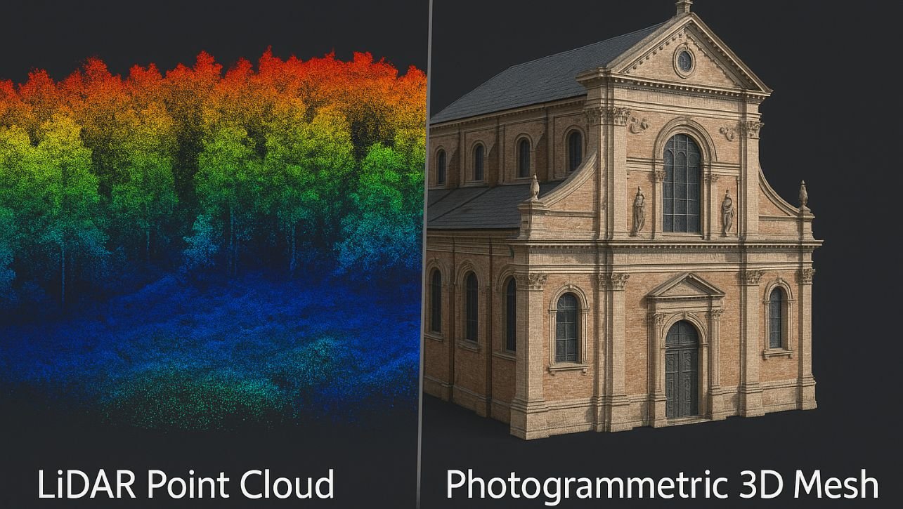
In the quest to digitally capture our world in three dimensions, two technologies reign supreme: LiDAR Vs. Photogrammetry. From creating immersive digital twins of cities to monitoring ancient archaeological sites, the demand for accurate 3D data has never been higher.
But if you’re planning a drone survey, an aerial mapping project, or a ground-based scan, you face a critical decision: which technology is right for you? The choice between LiDAR and Photogrammetry isn’t about one being universally “better”—it’s about matching the right tool to your project’s specific needs, budget, and deliverables.
This ultimate 2025 showdown will cut through the hype, giving you a clear, unbiased comparison to help you make the most informed decision.
The 30-Second Summary: LiDAR vs. Photogrammetry
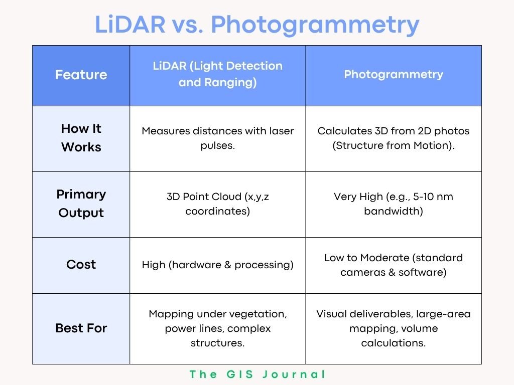
| Feature | LiDAR (Light Detection and Ranging) | Photogrammetry |
|---|---|---|
| How It Works | Measures distances with laser pulses. | Calculates 3D from 2D photos (Structure from Motion). |
| Primary Output | 3D Point Cloud (x,y,z coordinates) | 3D Textured Mesh & Orthomosaic |
| Accuracy (Vegetation Penetration) | Excellent. Can see through gaps to ground. | Poor. Sees only the top of the canopy. |
| Visual Realism | Poor (no inherent color/texture). | Excellent. Photo-realistic textures. |
| Speed of Data Capture | Very Fast (direct measurement). | Slower (requires high overlap). |
| Cost | High (hardware & processing) | Low to Moderate (standard cameras & software) |
| Best For | Mapping under vegetation, power lines, complex structures. | Visual deliverables, large-area mapping, volume calculations. |
The Deep Dive: How They Work
What is LiDAR? (The Laser Ruler)
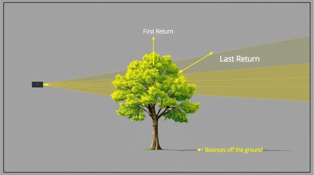
LiDAR is an active remote sensing method. It works by firing hundreds of thousands of laser pulses per second at a target and measuring the time it takes for each pulse to return to the sensor.
-
The “Point Cloud”: Each return creates a single point with precise X, Y, and Z coordinates. The result is a massive, dense “cloud” of individual points that accurately represents the scanned object or landscape.
-
Multiple Returns: A key advantage is that a single laser pulse can have multiple returns. It can hit a leaf, then a branch, and finally the ground, capturing data at different levels. This is what allows LiDAR to “see through” vegetation.
What is Photogrammetry? (The 3D Puzzle Solver)
Photogrammetry is a passive method. It uses overlapping 2D photographs taken from different positions to reconstruct a 3D model.
-
Structure from Motion (SfM): Sophisticated software identifies common points in multiple overlapping images. By triangulating the position of these points, it calculates their location in 3D space, creating a dense point cloud, which is then used to generate a 3D mesh.
-
The Textured Mesh: The software then drapes the original photographs over the 3D mesh, creating a photorealistic, “true-color” model.
Head-to-Head: The Key Comparison Factors
1. Accuracy and Detail
-
LiDAR: Excels in vertical (Z) accuracy and capturing fine linear details like wires, pipes, and sharp building edges. It is less affected by lighting conditions or surface textures.
-
Photogrammetry: Provides excellent horizontal (X,Y) accuracy. However, its vertical accuracy can be lower than LiDAR, especially in areas with uniform textures (like sand or grass) where the software struggles to find matching points.
Verdict: LiDAR wins for vertical accuracy and capturing fine details. Photogrammetry wins for horizontal accuracy on well-textured surfaces.
2. Dealing with Vegetation and Obstructions
This is LiDAR’s killer app.
-
LiDAR: Can penetrate small gaps in vegetation to map the ground terrain below, creating an accurate Digital Terrain Model (DTM). This is non-negotiable for forestry, floodplain mapping, and archaeology.
-
Photogrammetry: Can only see the top surface (the canopy), resulting in a Digital Surface Model (DSM). It cannot map what it cannot see.
Verdict: LiDAR is the undisputed winner for any project requiring ground data in vegetated areas.
3. Visual Output and Deliverables
-
Photogrammetry: The clear winner for visual appeal. Its outputs—orthomosaics and textured 3D meshes—are instantly recognizable and rich with visual information. This is ideal for presentations, asset inspections, and virtual tours.
-
LiDAR: Produces a monochromatic point cloud. While color can be added by fusing LiDAR data with camera imagery (“RGB LiDAR”), it is an extra step and rarely matches the visual quality of photogrammetry.
Verdict: Photogrammetry wins for visually communicative maps and models. LiDAR wins for pure geometric measurement.
4. Cost and Accessibility
-
Photogrammetry: Has a low barrier to entry. You can start with a consumer-grade drone and a $100/month software subscription. The technology is mature and widely understood.
-
LiDAR: Requires a significant investment. A professional drone LiDAR system can cost $30,000 – $100,000+.
Processing software is also more specialized and expensive. Furthermore, it requires greater expertise to operate and process the data correctly.
Verdict: Photogrammetry is far more cost-effective and accessible for most users.
5. Sunlight and Weather Dependence
-
LiDAR: An active sensor, it can be used day or night. It can also see through some haze and light fog, though heavy rain or fog will scatter the laser beams.
-
Photogrammetry: Requires good, consistent lighting. Shadows, glare, and overcast conditions that change between photos can ruin a dataset.
Verdict: LiDAR is more reliable for time-sensitive projects and can operate in a wider range of lighting conditions.
Read Also:
ArcGIS Pro vs. QGIS: The Ultimate 2025 Showdown (Pros, Cons & Verdict)
Multispectral vs. Hyperspectral Imagery: A Clear-Cut Guide For 2025
8 Common Map Projections: Which One is Right for Your Map?
When to Use Which: Your Project Guide
Choose LiDAR If Your Project Involves:
-
Forestry Management: Measuring timber volume, canopy structure, and creating DTMs.
-
Infrastructure Corridors: Mapping power lines, pipelines, and rail lines through vegetation.
-
Engineering & Construction: Capturing complex industrial sites with plenty of steelwork and piping.
-
Flood Modeling & Hydrology: Creating highly accurate terrain models of watersheds.
-
Archaeology: Discovering subtle ground features hidden under foliage (e.g., ancient earthworks).
Choose Photogrammetry If Your Project Involves:
-
Orthomosaic Map Creation: For high-resolution, “true-color” 2D base maps.
-
Construction Earthworks: Calculating stockpile volumes and cut/fill quantities.
-
Agriculture: Creating NDVI maps and monitoring crop health (requires a multispectral camera).
-
Cultural Heritage & Film: Creating photorealistic 3D models of buildings, statues, and sites for digital archives or visual effects.
-
Marketing & Real Estate: Creating stunning visualizations and virtual tours.
The Future is Fusion: The Hybrid Approach
The most powerful approach emerging in 2025 is data fusion—using both technologies on the same project.
How it works: A drone equipped with both a LiDAR sensor and a high-resolution camera captures data simultaneously.
The benefit: You get the geometric precision of LiDAR (e.g., an accurate DTM under trees) with the visual clarity of photogrammetry (e.g., a beautiful orthomosaic of the open areas). The LiDAR point cloud can be used to correctly classify the photogrammetric model.
The Final Verdict: LiDAR vs. Photogrammetry
The debate isn’t LiDAR versus Photogrammetry; it’s LiDAR and Photogrammetry as complementary tools.
-
For most visual, large-area mapping projects where cost is a factor, Photogrammetry is your best bet. It delivers stunning, accurate, and highly useful data for a wide array of applications.
-
When you need to see the ground through trees, capture fine details, or work in challenging light, LiDAR is worth the investment. It solves specific problems that photogrammetry cannot.
Your choice should be guided by a simple question: “What is the single most important deliverable for my project?” Answer that, and the path forward becomes clear. In an ideal world with an unlimited budget, you’d use both. But for everyone else, understanding this fundamental trade-off is the key to 3D mapping success.
FAQ: LiDAR vs. Photogrammetry
Q: Can photogrammetry be as accurate as LiDAR?
A: In open, well-textured areas with perfect ground control, photogrammetry can achieve centimeter-level accuracy that rivals LiDAR. However, LiDAR will always be more accurate in vegetated areas and for capturing sharp edges.
Q: What about mobile LiDAR vs. drone LiDAR?
A: Mobile LiDAR (mounted on a car) is superior for mapping urban corridors and roads at street level. Drone LiDAR is better for larger areas, difficult terrain, and capturing data from above.
Q: Is LiDAR data harder to process?
A: Yes. LiDAR processing requires specialized software and a deeper understanding of point cloud classification and filtering. Photogrammetry software is generally more user-friendly and automated.
Q: What’s the deal with “RGB LiDAR”?
A: This is a LiDAR system with a built-in camera that captures color (RGB) data. It then assigns this color value to each point in the point cloud, creating a more visually intuitive, but not photorealistic, deliverable.
1 thought on “LiDAR vs. Photogrammetry: The Ultimate 2025 Showdown (Pros, Cons & Verdict)”