
Geographic Information Systems (GIS) have become an essential part of data-driven decision-making across multiple industries—from urban planning and environmental monitoring to logistics, telecommunications, and even public safety. As we step into 2025, the demand for reliable GIS services is only growing stronger. In this blog, we list the top 10 GIS service providers in the USA for 2025, helping you choose the right partner for your next geospatial project.
Top 10 Best GIS Service Providers in USA
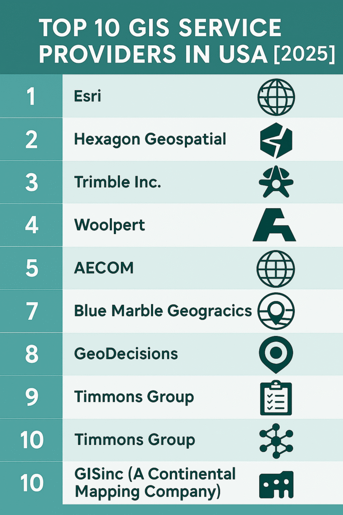
1. Esri (Environmental Systems Research Institute)
Headquarters: Redlands, California
Website: www.esri.com

Why Esri?
Esri is the global leader in GIS technology and services. Their flagship product, ArcGIS, is widely used by governments, businesses, and researchers around the world. Esri offers everything from mapping and spatial analysis to AI-powered location intelligence.
Key Services:
-
ArcGIS Platform
-
Spatial Data Analytics
-
Location Intelligence
-
Cloud GIS Solutions
2. Hexagon Geospatial
Headquarters: Madison, Alabama
Website: www.hexagongeospatial.com

Why Hexagon?
A part of Hexagon AB, this provider delivers powerful geospatial solutions through its Luciad and ERDAS product lines. They offer custom GIS services for defense, public safety, and transportation sectors.
Key Services:
-
Remote Sensing & Imagery Analysis
-
Real-Time GIS
-
Smart City Solutions
3. Trimble Inc.
Headquarters: Sunnyvale, California
Website: www.trimble.com

Why Trimble?
Trimble is a big player in geospatial technology, especially when it comes to surveying, construction, and agriculture. Their integration of hardware, software, and services provides end-to-end GIS solutions.
Key Services:
-
GNSS & Survey Equipment
-
Asset Management
Related Content:
12 Best Business Ideas for GIS Users in 2025
7 Powerful GIS Applications in Climate Science
Top 16 FREE Sources of GIS Vector Data (Updated 2025)
8 GIS Services That Make You Rich in 2025
4. Woolpert
Headquarters: Dayton, Ohio
Website: www.woolpert.com

Why Woolpert?
Woolpert offers comprehensive AEG (Architecture, Engineering, and Geospatial) solutions. Their GIS team provides data collection, LiDAR services, and enterprise GIS support to government and private clients.
Key Services:
-
LiDAR & Aerial Imagery
-
Enterprise GIS Consulting
-
Data Integration
5. AECOM
Headquarters: Dallas, Texas
Website: www.aecom.com

Why AECOM?
AECOM’s GIS team supports large-scale infrastructure and environmental projects. They bring deep industry expertise and robust data visualization tools to clients globally.
Key Services:
-
Environmental GIS
-
Infrastructure Planning
-
Urban Mapping
6. Dewberry
Headquarters: Fairfax, Virginia
Website: www.dewberry.com

Why Dewberry?
A trusted partner for government agencies, Dewberry excels in LiDAR, hydrography, and emergency management GIS services. Their team works on FEMA flood maps and other national-scale projects.
Key Services:
-
FEMA Mapping
-
Disaster GIS Support
-
Coastal Mapping
7. Blue Marble Geographics
Headquarters: Hallowell, Maine
Website: www.bluemarblegeo.com

Why Blue Marble?
Best known for the Global Mapper software, Blue Marble offers user-friendly GIS software and custom geospatial development services, ideal for both beginners and professionals.
Key Services:
-
Global Mapper Platform
-
GIS Training & Support
-
Coordinate System Customization
8. GeoDecisions
Headquarters: Camp Hill, Pennsylvania
Website: www.geodecisions.com

Why GeoDecisions?
GeoDecisions specializes in location-based intelligence solutions. They focus heavily on logistics, transportation, and public safety for both federal and commercial clients.
Key Services:
-
Web GIS Applications
-
Transportation Analytics
-
Custom GIS Solutions
9. Timmons Group
Headquarters: Richmond, Virginia
Website: www.timmons.com
Why Timmons Group?
Timmons Group has built a strong reputation in state and local government GIS. Their expertise lies in custom Esri-based solutions, mobile GIS, and geodatabase design.
Key Services:
-
GIS Planning & Implementation
-
Asset & Infrastructure Management
10. GISinc (A Continental Mapping Company)
Headquarters: Birmingham, Alabama
Website: www.gisinc.com
Why GISinc?
Recently acquired by Continental Mapping, GISinc is a seasoned Esri partner delivering end-to-end GIS services for government and commercial clients, including health, utilities, and public safety sectors.
Key Services:
-
GIS Strategy & Consulting
-
Esri-Based Solutions
-
Enterprise GIS Deployment
Final Thoughts
Whether you’re looking for enterprise-level GIS software, custom mapping solutions, or LiDAR services, the above providers are at the top of their game in 2025. Choosing the right GIS partner depends on your industry, budget, and project scope—but with this list, you’re off to a great start.
Need help choosing the right GIS service provider?
Drop your queries in the comments or contact us at The GIS Journal. We’re happy to guide you through your geospatial journey.
📌 Frequently Asked Questions (FAQs)
1. What is a GIS service provider?
A GIS service provider offers professional solutions related to Geographic Information Systems (GIS), including mapping, spatial data analysis, geospatial software development, remote sensing, and data visualization. These services help organizations make location-based decisions more efficiently.
2. How do I choose the best GIS company for my project?
When selecting a GIS service provider, consider the following:
-
Industry experience (e.g., government, agriculture, urban planning)
-
Technology stack (e.g., Esri, QGIS, remote sensing tools)
-
Client portfolio and case studies
-
Certifications and partnerships (like Esri Silver/Gold Partner)
-
Scalability and support for enterprise-level solutions
3. Are these GIS companies suitable for small businesses and startups?
Yes, many companies on the list (like Blue Marble Geographics, Timmons Group, and GeoDecisions) offer scalable and affordable solutions tailored for small businesses, local governments, and startups.
4. What industries benefit the most from GIS services?
GIS services are widely used in:
-
Urban and regional planning
-
Agriculture and precision farming
-
Environmental monitoring
-
Disaster management
-
Transportation and logistics
-
Utility and infrastructure management
-
Real estate and retail site selection
5. Which is the most widely used GIS software in the USA?
Esri’s ArcGIS platform remains the most widely adopted GIS software in the USA, used by federal agencies, municipalities, universities, and private organizations.
6. Do GIS service providers also offer custom app development?
Yes. Several companies like GISinc, Timmons Group, and GeoDecisions specialize in building custom GIS web and mobile applications based on your specific needs using platforms like ArcGIS, Leaflet, and OpenLayers.